Mapping Racial Groups by Percentage
in Counties across the United States

The first map is of the percentage of African-American population in the United States by county. The first impression after glancing at this map is that there is very few African-Americans compared to other races, in most of the Midwestern, northwestern, and southwestern states. Although there are slightly higher percentages in the northeastern states, the highest proportions of African-Americans are in the South. It should not be assumed that there are higher concentrations of African-Americans in the southern states; this map only demonstrates where African-Americans are the majority, denoted by the dark green colors (40-90%). African-Americans represent the majority in many counties in the South, which can probably be explained by historical factors. In the time of slavery, African-Americans accounted for an even higher proportion of the population than they do now, due to a small population of white slave-owners and the large number of slaves brought to the South. For various cultural and socio-economic factors, the African-American population has remained as a majority in the South.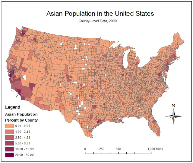

After examining the map of the African-American population, the percentage of Asians in each county seems much smaller in comparison. The trends in the map of the percentage of the Asian population in the United States are quite the opposite of what was observed in the previous map. The immigration of Asians to the United States was very different from the forced immigration of the Black population. The first major wave of Asian immigrants occurred in the 1850’s due to the California Gold Rush. This lucrative gold search led to a demand for labor to mine gold, harvest food, and construct the railroad. There was also a demand for laborers in the northeast during the industrial revolution. These two historical events deeply influenced the spread and proportion of the Asian population even to this day, as demonstrated by this map.

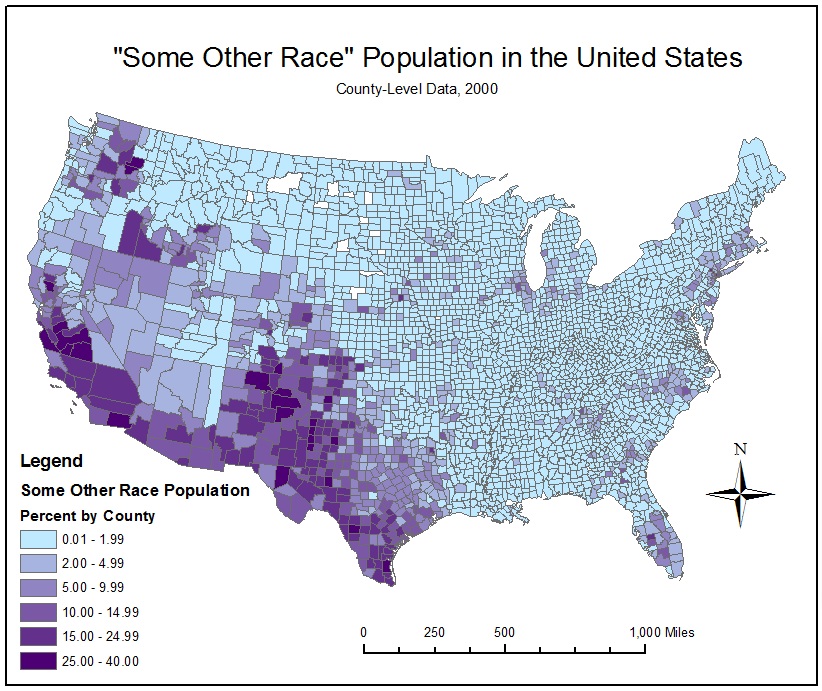
Although there are several apparent trends in the proportions of “Some Other Race” in counties across the United States, it is difficult to decipher the causes of these patterns because of the ambiguous nature of the racial category. According to the Census definition, “Some Other Race” includes all other responses not included in the specified race categories. This category is mostly comprised of individuals that provided write-in entries, such as multiracial, mixed, interracial, or a specific Hispanic group. Therefore, this map of the percentage of “Some Other Race” by county may reveal the high proportion of mixed-race individuals and Latinos throughout the southwestern states. However, it may be unwise to create policies or make important decisions based on this assumption. Instead the census should be altered to account for the growing number of mixed-race individuals and eliminate the ambiguity of the category of “Some Other Race”.
Conclusions about Census Maps:
Conclusions about Census Maps:
After examining these maps representing the respective percentages on African-Americans, Asians, and “Some Other Race”, there are a few important observations to be made. There are several elements of this map-making process that can lead to misconceptions about the proportions of racial groups in the United States. First of all, it is essential to clearly communicate to map-users that this map shows proportions, not concentrations. This process is strongly influenced by overall population of each county. For example, a county with a very small population could have a high proportion of Asians, but a larger county with a small proportion of Asians may still have a higher number of Asians. Another possible misconception is the result of inadequate definitions of race. Due to the United States’ history as a beacon for immigrants, race is a complex issue and difficult to define. It is essential to alter census categories to account for Americans’ evolving concept of race especially in the case of mixed race and interracial groups.
Conclusions about GIS:
Throughout this class I have discovered the great potential of GIS in revealing the spatial component of information and data. Sometimes this information can be about physical attributes, such as the burned area of a wildfire, or it can more abstract, such as the proportion of racial groups. The data used to create GIS maps first exists in tables as numbers, which are often analyzed mathematically using statistics to discover patterns. Although statistical data is often helpful in discovering trends in data, incorporating a spatial component enables the mapmaker to view the big picture. However, with great potential come opportunities for misinformation. It is essential for mapmakers to thoroughly state the characteristics of the map so that the map-users’ interpretation is not skewed. The reliability of a GIS map depends on the accuracy of the input data and the proficiency of the mapmaker to correctly assemble the various elements of the map. I look forward to learning more about the capabilities of GIS and becoming a worthy mapmaker.
Throughout this class I have discovered the great potential of GIS in revealing the spatial component of information and data. Sometimes this information can be about physical attributes, such as the burned area of a wildfire, or it can more abstract, such as the proportion of racial groups. The data used to create GIS maps first exists in tables as numbers, which are often analyzed mathematically using statistics to discover patterns. Although statistical data is often helpful in discovering trends in data, incorporating a spatial component enables the mapmaker to view the big picture. However, with great potential come opportunities for misinformation. It is essential for mapmakers to thoroughly state the characteristics of the map so that the map-users’ interpretation is not skewed. The reliability of a GIS map depends on the accuracy of the input data and the proficiency of the mapmaker to correctly assemble the various elements of the map. I look forward to learning more about the capabilities of GIS and becoming a worthy mapmaker.
Citations:
No comments:
Post a Comment